


AR GPS Compass Map 3D

AR GPS Compass Map 3D의 설명
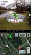
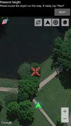
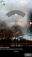
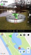
3D Compass and Waypoint Finder with Map and Augmented Reality Display!This is theFree-Version. There is also aPro-Versionavailable. Please check my other apps, you can find it there.Features (Summary):*Augmented Reality display*High precision and stability (special filter algorithm)*Map with GPS Location*Displays GPS information*Measure the height of large objects*Measure magnetic field strength (metal detector)*Magnetic field strength warning (indicates magnetic influences)*Geocaching: Easily define and find waypoints*Share waypoints or your current location with other users*Define waypoints by specifying latitude / longitude in various formats*Define waypoints by a long-press on the map*Define waypoints by specifying distance and bearing*Real3D support!Detailed description:Augmented Reallity GPS Compass Map 3D displays a 3D compass that gets combined with the camera image. Your current location from GPS is shown on a separate map with adjustable size.
Unlike most other apps, the compass uses a very effective fusion and filtering algorithm to combine the values of the magnetic field sensor, the accelerometer and the gyroscope (if installed in your device) to achieve a maximum in precision and stability.
A magnetic field strength warning indicates the possible influence of metallic objects or power-lines.
You can define your own waypoints. In this case a green arrow on top of the compass always points towards the selected waypoint. (Geocaching is really fun with it :-)
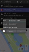
New waypoints can be defined by a long-click on the map, by specifying latitude and longitude, or by specifying distance and heading from an existing waypoint.
You can also share your current location and the locations of your waypoints with your friends.
On devices with LG's Real3D technology (e.g. the LG P920 Optimus 3D or the LG P720 Optimus 3D Max), the app features a 3D stereoscopic view of the compass and the camera image.
The app is still being developed further, so please feel free to send your comments or suggestions to the developers e-mail address provided below. Your feedback is highly appreciated!Keywords: Augmented Reality, GPS, Compass, Map, 3D, Real3D, Geocaching, Waypoint navigation, Measure, Geodesic lines, Metal detector, Magnetic field strength warning, Gyroscope, Accelerometer, Magnetometer지도와 증강 현실 디스플레이! 을 함께다운로드 3D 나침반과 중간 지점 찾기
이건의자유 버전 을 클릭합니다. 이 또한다운로드프로 버전 를 사용할 수 있습니다. 내 다른 앱을 확인하십시오, 당신은 여기에서 찾을 수 있습니다.다운로드기능 (요약) :다운로드 * 를 증강 현실 디스플레이다운로드 * 을 높은 정밀도와 안정성 (특별 필터 알고리즘)다운로드 GPS 위치와 함께 * 지도다운로드 * 을 표시 GPS 정보다운로드 * 를 대형 개체의 높이를 측정다운로드 * 을 측정 자기장 강도 (금속 탐지기)다운로드 * 을 자기장 강도 경고 (자기의 영향을 나타냅니다)다운로드 * 을 Geocaching : 쉽게 중간 점을 정의하고 찾아다운로드 * 을 공유 경유지 또는 현재 위치 다른 사용자들과다운로드 다양한 형식으로 위도 / 경도를 지정하여 * 를 정의 경유지
지도에서 오랫동안 기자로다운로드 * 을 정의 경유지다운로드 지정 거리와 베어링에 의해 * 를 정의 경유지다운로드 * 을 Real3D 지원!다운로드상세 설명 사항 : 를
복합 Reallity GPS 나침반 맵 3D는 카메라 이미지와 함께됩니다 3D 나침반을 표시합니다. GPS에서 현재 위치를 조절 크기가 별도의지도에 표시됩니다.
대부분의 다른 응용 프로그램과는 달리, 컴퍼스는 매우 효과적인 융합 자기장 센서, 가속도계 및 정밀도와 안정성에 최대를 달성 할 수있는 자이로 스코프 (귀하의 장치에 설치 한 경우)의 값을 결합하는 필터링 알고리즘을 사용합니다.
자기장 강도 경고 금속성 물체 나 전원 라인의 가능한 영향을 나타냅니다.
당신은 당신 자신의 중간 점을 정의 할 수 있습니다. 이 경우 나침반 위에 녹색 화살표는 항상 선택된 좌표를 향해 가리 킵니다. (Geocaching는 :-)와 정말 재미
새로운 중간 지점은 위도와 경도, 또는 거리를 지정하고 기존의 중간 점에서 제목에 의해 지정하여지도에 오랜 클릭하여 정의 할 수 있습니다.
당신은 또한 당신의 친구와 현재 위치와 중간 점의 위치를 공유 할 수 있습니다.
LG의 Real3D 기술 (예 : LG P920 옵티머스 3D 나 LG P720 옵티머스 3D 맥스)와 장치에서 응용 프로그램은 나침반과 카메라 이미지의 3D 입체 전망을 즐기실 수 있습니다.
응용 프로그램이 아직 더 개발되고 있으므로 아래의 개발자 전자 메일 주소로 여러분의 의견이나 제안을 보내 주시기 바랍니다. 귀하의 의견은 매우 감사합니다!키워드 : 증강 현실, GPS, 나침반,지도, 3D, Real3D, Geocaching, 중간 지점 탐색, 측정, 측지 선, 금속 탐지기, 자기장 강도 경고, 자이로 스코프, 가속도계, Magnetometer 을

AR GPS Compass Map 3D - APK 정보
APK 버전: 1.6패키지: com.kettler.argpsc3dAR GPS Compass Map 3D의 최신 버전
다른 버전들


동일 카테고리의 앱


